Search For Maps & Articles

Showing posts with label warning devices. Show all posts

Where Are Solar Speed Radar Signs Located? A Complete Guide

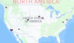
Just a reminder that we are tracking these solar speed radar sign locations. 

usa map

Where Are Solar Speed Radar Signs Located?
Solar-powered speed radar signs — sometimes called “speed radar signs” — are becoming more common on U.S. roadways. These devices don’t issue tickets; instead, they detect a vehicle’s speed and flash a warning when a driver is exceeding the limit. They act as a visual reminder to slow down, rather than as an enforcement tool. At PhotoEnforced, we’re actively tracking the locations of these radar signs across the country and maintaining a public map. As of May 2020, we’ve cataloged 53 known speed radar signs and continue to add new ones based on submissions from our users and field observations.

What Are Solar Speed Radar Signs?

Unlike conventional speed cameras that generate tickets, solar radar signs are passive warning systems. Their main features:

  • Solar-powered: They run off solar panels, so they’re self-sustaining and don’t require external wiring or grid power.

  • Non-ticketing: They detect when you exceed the posted speed limit and flash a warning, but they don’t issue citations or capture your license plate for enforcement.

  • Awareness tool: Their goal is to encourage safer driving behavior in sensitive or hazard-prone zones, such as near schools, parks, or residential streets.
    Because they’re low-cost, easy to deploy, and non-intrusive in terms of power infrastructure, they are increasingly popular in areas where cities want to improve safety without installing full-fledged automated enforcement systems.

Why Track Their Locations?

Knowing where these radar signs are placed is useful for several reasons:

  1. Road safety awareness: Drivers who are aware of radar sign locations may slow down in those areas. That in turn helps reduce speed-related crashes or near-misses, especially in zones with higher pedestrian traffic.

  2. Community transparency: Since these signs are not enforcement devices (they don’t issue tickets), mapping them helps differentiate them from speed cameras. This clarity helps citizens understand what’s warning versus what’s enforcing.

  3. Data and planning: Municipalities, planners, and researchers can use the location data to analyze patterns: which roads tend to get these signs, how effective they are, and where future deployments might make sense.

  4. Public engagement: Because some of the deployments come from community or grassroots efforts, having a shared map allows civic-minded drivers to report signs, verify them, or question whether more are needed in their area.

Where You’ll Find Them

From our database and reports, radar signs tend to cluster in certain kinds of zones:

  • School zones & around schools: Areas where children cross streets or walk frequently are high-priority locations for visual speed reminders.

  • Parks, playgrounds, and recreation areas: When there’s pedestrian activity or relaxed street design, these zones often see radar signs.

  • Residential neighborhoods: In streets with local traffic but speed issues, particularly those adjacent to schools or parks, radar signs are often used to calm traffic.

  • Transition zones or gateways: At places where speed limits change—such as when entering a lower-speed residential or school zone—the radar signs act as a reminder as drivers transition from faster roads.

  • Spots with crash history or safety concerns: Roads with a history of speeding crashes or near-misses may get radar signs as part of a “fix-it-first” safety approach.
    Because the devices are solar powered and relatively simple, they’re well-suited for roads where traditional enforcement systems would be expensive or impractical.

How to Add a Radar Sign to the Map

If you spot a solar radar sign and it’s not yet on the PhotoEnforced map, you can submit a location. Typically, you’ll need:

  • A photo of the sign (to confirm it’s indeed a radar sign and not an enforcement camera).

  • The address, intersection, or GPS coordinates.

  • Any additional notes (e.g. speed limit posted, direction of travel, nearby school or park).
    These crowd-sourced submissions help expand the map’s coverage and accuracy. Over time, as more people contribute, the database becomes more robust and useful for all.

Current Count & Map

As of May 2020, we’ve logged 53 solar radar signs. The map is publicly available and updated as new signs are verified and added. We encourage readers to contribute signs they’ve encountered. To explore current entries or add a sign yourself, you can use the PhotoEnforced “Add Speed Radar” submission tool and browse the interactive map. The map includes icons for each sign, letting users see where they are scattered across different states and regions. The map is not static — it’s updated regularly as contributors submit new locations or validate existing ones.

Why They Are Increasing in Use

Several advantages make solar radar signs appealing for communities and transportation departments:

  • Lower cost and easier deployment: Because there’s no wiring or grid connection, solar radar signs can be installed more cheaply and flexibly than full enforcement cameras.

  • Reduced controversy: Since they don’t issue tickets, these signs are less contentious from a policy or legal standpoint. They are more readily accepted by communities wary of automated enforcement.

  • Behavioral impact with less intrusion: Studies and anecdotal evidence suggest that visual feedback—“you’re driving too fast” flashing signs—can lead to voluntary speed reduction, especially in familiar areas.

  • Scalable & modular: You can place them in many locations (e.g. school zones, side streets) without committing to more complex camera systems.

  • Public relations & safety image: For local governments, installing radar signs is often seen as a safety-friendly move, signaling to constituents that authorities care about local road speed and pedestrian safety.

Limitations & Considerations

Despite their benefits, there are a few caveats:

  • Effect may wear off: Over time, drivers may habituate to the signs and stop reacting to the flashing when exceeding the speed limit.

  • No enforcement power: Because they don’t capture license plates or issue fines, their effect relies entirely on voluntary compliance.

  • Placement matters: If a sign is off to the side, hidden by foliage, or not well aligned with the roadway, drivers may not see it in time for the visual cue to be meaningful.

  • Not a substitute for enforcement in high-risk areas: In zones with chronic speeding or dangerous crash histories, stronger enforcement tools may still be needed in conjunction with radar signs.

  • Maintenance & calibration: Even though they are simpler than cameras, radar signs need upkeep — solar panels need cleaning, the equipment must be calibrated, and the electronics must be protected from tampering or vandalism.

What You Can Do as a Driver or Citizen

  • Learn where they’re located: Use the interactive map to see whether any radar signs are near your home, school, or commute path.

  • Help expand the map: If you see a new sign, submit it — a photo, location, and some details go a long way.

  • Drive more mindfully: The presence of a flashing radar sign is an indicator: you’re in a zone where speed is a concern, so slow down and be alert to pedestrians, intersections, or children.

  • Advocate locally: If your community lacks radar signs in high-risk corridors, you can suggest them to your transportation or public works departments as low-cost safety tools.

We call these locations "speed radar signs" in our database.  The new speed radar signs are typically solar-powered like this image below.  They don't issue tickets but flash when you are going over the speed limit to warn you to slow down.  


These new cameras are popping up all over the place and you can easily add them to our database here.  The locations are important to track in the database because they are typically dangerous locations around schools, parks, and schools.  

Submit a new solar speed radar sign here. 

Why Are Mapping Companies Afraid to Publish Camera Locations?

black, red, yellow country shape 

In an age where real-time traffic updates, satellite imagery, and AI-powered routing are commonplace, one question stands out: Why do most mapping companies avoid showing speed and red-light camera locations? With drivers increasingly reliant on navigation apps like Google Maps, Apple Maps, and Waze, the lack of transparency around traffic enforcement camera locations raises serious concerns about data censorship, user trust, and government influence.

The Growing Demand for Camera Location Transparency

Speed and red-light cameras are now widespread across major U.S. cities—from New York to Chicago to Los Angeles. These cameras are marketed as tools to improve public safety by deterring dangerous driving behaviors. But many critics argue they're also a revenue-generating tool for municipalities.

For drivers, knowing the location of speed and red-light cameras isn't just about avoiding tickets—it's about making informed driving decisions. That’s why demand for apps and websites that publish camera locations has skyrocketed. So why aren’t the biggest names in mapping fully supporting this?

1. Legal and Regulatory Pressure

Mapping giants operate globally, which means they face a complex patchwork of local laws and regulations. In some countries, publishing the location of speed enforcement cameras is outright banned. Even in the U.S., some jurisdictions have lobbied against features that reveal camera locations, arguing it undermines public safety efforts.

Is It Illegal in Germany and Europe?

Yes—and this is a major reason mapping companies remain cautious.

In Germany, it is illegal to use or operate apps or devices that provide real-time speed camera alerts while driving. Section 23(1c) of the German Road Traffic Act prohibits using such functionality in vehicles, and violators face fines and points on their license. Passive knowledge (like memorizing camera locations or checking before the drive) is allowed—but live alerts during driving are banned.

Here’s a snapshot of laws in Europe:

Country Legal to Use Speed Camera Alerts While Driving?
Germany ❌ Illegal
France ❌ Illegal (workarounds like "danger zones" used)
Switzerland ❌ Very illegal—even owning the app
UK ✅ Legal for fixed cameras
Netherlands ✅ Generally allowed
Italy/Spain ✅ Mixed enforcement

Because mapping companies often deploy uniform global features, they tend to restrict or blur enforcement camera data in countries with strict laws—sometimes impacting their features even in more lenient regions.

2. Fear of Political and Governmental Backlash

Publishing camera locations can put tech companies at odds with local governments and law enforcement agencies. These partnerships are often essential for access to infrastructure data, transit updates, and emergency response systems.

Criticizing or circumventing traffic enforcement tools might jeopardize those relationships. For some companies, avoiding conflict with city governments is more important than serving driver interests.

3. Liability and Public Safety Concerns

Mapping companies must also weigh ethical concerns. Critics of camera alerts argue that making camera data widely available could encourage reckless driving—drivers might only slow down near known camera points and speed elsewhere.

This puts companies in a tough position: if someone misuses the information and causes harm, could the platform be held partially responsible? To avoid these murky liability waters, many simply choose not to include real-time camera data.

4. Data Sourcing Challenges

Another overlooked factor is data reliability. Camera installations frequently change—new ones are added, and older ones are decommissioned or relocated. Maintaining an accurate, up-to-date global database of camera locations is a monumental task that requires constant local data verification.

Crowdsourced platforms like Waze have made strides in this area, but even then, accuracy varies widely by location. This makes it hard for major players to justify large-scale implementation, especially if the data can't be verified.

5. The Rise of Independent Alternatives

With mainstream mapping tools reluctant to offer full camera visibility, independent websites and apps are stepping in to fill the gap. Platforms like Speedtrap.org, PhotoEnforced.com, and various Reddit forums crowdsource camera location data and provide regularly updated maps.

Conclusion: Transparency vs. Control

At the heart of the issue is a clash between driver autonomy and centralized control. Mapping companies may cite safety, compliance, and legal complexity as reasons to hide traffic camera data, but users are growing increasingly skeptical. In a digital era built on open data and real-time insights, the decision to withhold information feels outdated—and potentially manipulative.

If companies like Google and Apple want to maintain user trust, it might be time to embrace camera transparency and let drivers make informed choices.

Speed Camera Chime on Tesla: How to Enable It & Stay Alert on the Road

Tesla vehicles come packed with cutting-edge technology designed to enhance driving safety and convenience. One such feature that has garnered attention is the speed camera chime—a useful alert that notifies drivers of upcoming speed cameras. This feature helps drivers stay aware of speed limits and avoid unexpected fines.

How the Speed Camera Chime Works

Verra Mobility (VRRM) Stock Hits All Time Highs


Verra Mobility (ticker symbol VRRM) is a company that specializes in technology solutions for the transportation industry, including tolling, red-light enforcement, and traffic management. If the stock hit all-time highs, it suggests that the company's performance and investor sentiment have been positive, driving the stock price to new records.

BMWs Warn Drivers Of Speed Traps And Red-Light Cameras

BMWs Warn Drivers Of Speed Traps And Red-Light Cameras

Talk about an idea that’s long been overdue, especially for cars that are built to be driven aggressively. Some newer BMW models can now be upgraded with a system that warns drivers of the presence of speed detection devices and red-light cameras in the road ahead. That would make BMW the first automaker to sell cars that both help drivers get—and avoid getting—speeding tickets.

Called the Traffic Camera Information system, it’s part of BMW’s ConnectedDrive suite of high-tech in-car services that otherwise include real-time traffic alerts, advanced smartphone and Amazon Alexa connectivity and advanced voice control features. Powered by Here Technologies and Cedar Electronics, it’s similar to a function already being offered as part of the Waze traffic information system. Only rather than rely on reports of speed detection devices submitted by other motorists as Waze does, BMW’s system is based on a nationwide database of installations backed up by a network of radar detectors.

The speed-trap detection function is being offered as a three-month free trial on select 2021 models built after July 1, 2020 and equipped with BMW’s Live Cockpit Professional system. Owners can find more details about the service and check to see if it’s available their vehicle on the BMW ConnectedDrive Store website.

After the trial period expires, users will be asked to sign up for the service on a subscription basis at $25 for 15 months, which seems dirt cheap compared to having to pony up $100 or more to settle a speeding ticket. It’s not the first and certainly won’t be the last subscription-based option BMW will offer as a way to fuel ongoing revenues.

Which states allow speed cameras?


Is TomTom Red Light Camera Database Accurate?

TomTom is another well-known provider of GPS navigation systems and services, including red light camera alerts. While I don't have access to real-time information or data about the accuracy of TomTom's red light camera database, it's worth noting that such databases can vary in accuracy.

Similar to Garmin or other GPS navigation providers, TomTom strives to maintain accurate and up-to-date information regarding red light cameras. However, the accuracy of their database may still depend on various factors, such as the frequency of updates, changes in traffic laws, and the installation or removal of red light cameras.

To ensure the most accurate and current information, it's generally recommended to regularly update your TomTom device's software and firmware. It's also important to stay aware of local traffic laws and regulations related to red light cameras and always exercise caution when approaching intersections, regardless of the information provided by a GPS device.

If you have specific concerns or questions about the accuracy of TomTom's red light camera database, it would be best to contact TomTom's customer support directly. They can provide you with more detailed information about their data sources, update procedures, and any other inquiries you may have.

See related story:

Is Garmin's Red Light Camera Database Accurate?

Garmin, as a well-known GPS navigation and technology company, provides various services and features, including red light camera alerts in some of their devices. However, the accuracy of their red light camera database can vary.

It's important to note that red light camera databases are constantly being updated due to changes in traffic laws, new camera installations, removals, and other factors. While Garmin strives to keep its databases accurate and up-to-date, it's possible that occasional inaccuracies or delays in updating the information can occur.

To ensure the most accurate and current information, it's recommended to regularly update your Garmin device's software and firmware. Additionally, it's always a good idea to stay aware of local traffic laws and regulations regarding red light cameras, as well as exercise caution, and observe traffic signals when approaching intersections.

We met with Garmin management and they seemed content with sourcing red light camera data from an unnamed company in Europe that provides no sources for its database.  As long as Garmin's executives seem satisfied with being behind the curve and not having a complete dataset that is what their customers will get.  Please retweet and post comment on this post if you would like to see our red light content added to the Garmin platform. I don't think management is going to change their data provider unless consumers protest.

See related story:
TomTom Red Light Camera Database is Crap

How Many People Are Injured Each Year By Drivers Running Red Lights?

most dangerous cities drivers running red lights
Most Dangerous Cities for Drivers Running Red Lights

Red Light Running Accidents: Injuries, Fatalities, and Solutions in 2025

Every year in the United States, tens of thousands of people are injured or killed because of drivers who run red lights. This behavior, often seen as a minor traffic violation, continues to cause some of the most devastating crashes on American roads. The impact is far greater than just a ticket or fine. Red light running leads to life-changing injuries, fatalities, increased insurance costs, and billions in economic losses. With new data available in 2025, it is clear that the problem is ongoing, and addressing it remains a top priority for traffic safety experts and communities across the country.

Researchers found that violations dropped by 36% after yellow lights were extended to give drivers more warning that the light was about to turn red. After red light cameras were added, the remaining violations dropped by 96%.   

Rank City Estimated Annual Fatalities from Red Light Running Key Risk Factors
1 Washington, D.C. 75 High traffic volume, complex intersections, frequent violations
2 Philadelphia, PA 68 Dangerous arterial roads like Roosevelt Boulevard, pedestrian exposure
3 Houston, TX 65 Wide intersections, heavy commuter traffic, speeding culture
4 Los Angeles, CA 60 Congested freeways, long waits at signals, aggressive driving
5 Chicago, IL 55 Dense urban intersections, mix of vehicles, cyclists, and pedestrians
6 Phoenix, AZ 52 Large suburban intersections, high speeds, rapid growth areas
7 Dallas, TX 50 Expansive roadway network, fast-moving traffic, poor compliance
8 Miami, FL 48 Tourist traffic, distracted driving, high pedestrian density
9 New York, NY 45 Congestion, constant gridlock, mix of cars, bikes, and pedestrians
10 Atlanta, GA 43 Sprawling metro area, poor intersection design, high commuter stress

The Scope of the Problem

Running a red light may last only a few seconds, but the consequences can last a lifetime. In the United States, more than 136,000 people are injured each year in crashes involving red-light violations. These injuries range from broken bones to traumatic brain injuries and long-term disabilities. On top of that, around 1,100 people are killed annually in red light running crashes. The numbers have remained stubbornly high over the past decade, even with advancements in vehicle technology and roadway engineering.

What makes these statistics especially troubling is that roughly half of those injured or killed are not the violators themselves. Instead, they are pedestrians, bicyclists, and other drivers who are simply in the wrong place at the wrong time. Innocent people often pay the price for another driver’s reckless decision.

Why Drivers Run Red Lights

Understanding why drivers run red lights is key to preventing these crashes. Some of the most common reasons include speeding, distracted driving, and aggressive driving behaviors. Drivers in a rush may try to beat the yellow light but miscalculate the timing. Others may be distracted by a cell phone, navigation screen, or conversation and fail to notice the signal has changed. Impairment due to alcohol or drugs also increases the likelihood of running a red light. In some cases, intersections with short yellow light durations or poorly timed signals contribute to the problem, giving drivers less time to react.

Types of Crashes Caused by Red Light Running

The most common and dangerous type of crash caused by red light running is the T-bone or side-impact collision. These crashes occur when a vehicle traveling straight through a red light collides with a car entering the intersection from the side. Because the sides of vehicles have less protection than the front or rear, these collisions often cause severe injuries or fatalities. Other crashes include rear-end collisions, where a driver slams on the brakes to avoid running a red light, and pedestrian crashes, where walkers in crosswalks are struck by vehicles that fail to stop.

The Human and Economic Toll

Beyond the personal tragedies of injury and loss of life, red light running has a major economic impact. The costs include emergency medical services, long-term health care, property damage, legal expenses, and lost productivity. Insurance premiums also rise for communities with high crash rates, impacting everyone on the road. Estimates place the economic cost of red light running crashes in the billions of dollars annually. For families, the emotional toll is immeasurable, as survivors often deal with grief, post-traumatic stress, and long-term rehabilitation.

Enforcement and Red Light Cameras

To combat the problem, many cities and states have turned to automated enforcement systems such as red light cameras. These cameras capture violations and issue tickets by mail, increasing the likelihood that violators are held accountable. Research shows that intersections with cameras see fewer violations and reductions in fatal crashes. Some studies have reported drops of more than 20 percent in fatal red light running crashes after cameras were installed. However, the use of cameras is controversial in some communities, with opponents arguing about fairness, accuracy, and revenue motives. Still, when combined with proper signal timing and public awareness, cameras remain one of the most effective tools for reducing violations.

The Role of Signal Timing

Another proven method of reducing red light running is adjusting the timing of yellow and all-red intervals at intersections. Extending the yellow light by even one second can dramatically reduce violations, giving drivers more time to make a safe decision. Adding a brief all-red phase, where all directions remain red for a second or two, can also reduce the chance of vehicles entering the intersection while others are still clearing. These engineering solutions are cost-effective and widely supported by safety experts.

Public Awareness and Education

Education campaigns play a critical role in changing driver behavior. National campaigns such as “Stop on Red Week” highlight the dangers of red light running and encourage safe driving habits. Local initiatives, including driver education programs and community outreach, remind drivers that running a red light is not just a traffic violation but a dangerous choice that puts lives at risk. Emphasizing that most victims are innocent road users helps build support for enforcement and safer roadway design.

Technology and Vehicle Safety

Advancements in vehicle technology are also contributing to the fight against red light running. Many new cars are equipped with forward collision warning systems, automatic emergency braking, and lane departure alerts. Some vehicles now include intersection assist features that monitor traffic signals and warn drivers if they attempt to run a red light. As these technologies become more common, they have the potential to reduce crashes significantly. However, widespread adoption will take time, and driver behavior remains the biggest factor.

Intersection Design Improvements

Cities are investing in safer intersection designs to protect all road users. Roundabouts, for example, eliminate red lights entirely and reduce the severity of crashes by lowering speeds and changing the angle of impact. Protected left-turn signals, pedestrian countdown timers, and better lighting also contribute to safer intersections. These improvements not only reduce red light running but also improve the overall flow of traffic.

The Future of Red Light Safety

Looking ahead, the combination of automated enforcement, vehicle technology, roadway engineering, and education offers hope for reducing red light running crashes. Data shows that when communities commit to these measures, lives are saved. However, enforcement must be fair, transparent, and combined with efforts to improve signal timing and intersection safety. With over a hundred thousand people still injured every year and more than a thousand lives lost, there is no question that red light running remains a national safety priority.

Conclusion

Red light running is not a minor traffic infraction but a serious public safety issue. Every year, more than 136,000 people are injured and about 1,100 are killed in crashes caused by drivers who fail to stop at red lights. Half of the victims are innocent pedestrians, cyclists, and other drivers. While technology and enforcement are making progress, the problem persists. Through stronger enforcement, better intersection design, improved vehicle safety features, and public education, the United States can continue to reduce the toll of these preventable crashes. The ultimate goal is simple: ensuring that everyone gets through intersections safely, without fear of being struck by someone who chose not to stop.

List of Red Light Camera Warning Devices

red light cameras

Red light cameras and speed cameras are always changing on a daily basis.  There are approximately 10,000 locations in the United States today.  Here are some of the warning devices sold at retail stores and online at Amazon.  As a disclaimer, none of these companies license our data so there is no guarantee that their devices will have accurate warning notifications.

Share and review these devices on our individual product pages for each company.  Shop for radar detectors on Amazon: 

Cobra Radar Detectors
Escort Radar Detectors
Garmin Navigation Devices
TomTom Navigation
GPS Angel Radar
Magellan Navigation

Please email us if we are missing any companies that should be on this list.  

Do All Red Light Camera Intersections Have Warning Signs?

Every Camera Enforced Intersection DOES NOT Have Warning Signs 

The California Vehicle Code only requires that warning signs be posted to notify drivers of camera enforced intersections and that these signs be posted either at all approaches to the intersection or at all main entrances into a city including (freeways, bridges, and state highway routes).

Have you ever wondered why there are photo enforced warning signs for red light cameras at some intersections but not all them? The vehicle code VC§ 21455.5 says (a) (1), “Warning signs must be posted at each camera-equipped intersection and visible to traffic approaching from all directions, or at all the main entrances to town including, at a minimum, freeways, bridges, and state highway routes." The purpose of this law is to make sure that drivers are warned in all instances where there is red light camera enforcement.

Many times you will see warning signs posted right next to the traffic signal light, however not always. Sometimes warning signs might even be posted at the previous, non- camera enforced intersection which can be misleading or cause confusion. So while a City may not be in violation of the Vehicle Code requirements if they don’t have warning signs placed at the intersection (since they have a choice in the placement), if any signs you do find are blocked or damaged in a such a way you can’t see them, then you may have something that can help you in getting your ticket dismissed because warning signs do have to be reasonably visible. Be sure to take pictures of the signs to show they are not visible and take them to court with you or include them with your Trial by Written Declaration if you choose to fight your ticket in writing using form TR-205 (available at your local courthouse).

Contributed by ticketbust, helping drivers contest and dismiss their traffic tickets.

Radar Detectors at Best Buy & Amazon


Best Buy & Amazon Radar Detectors on Sale

While shopping today we discovered the following devices on display at Best Buy.  The store was located in California so it's not surprising that the aisle was empty since it's virtually impossible to get a speeding ticket on congested roads.  However, we were wondering if any of these devices had GPS inside and were able to warn you if you were getting close to any red light cameras?


The Passport 9500ix is the only device that uses satellites for GPS navigation to pinpoint your exact location and compares it to the detector's on-board database of red light and speed camera locations.  An alert goes off as you approach an intersection with an audible and visual alert.  There is no information on how the company has acquired its database of locations and no information on how to update it.  If they truly want to have industry incredibility about the number of locations I would recommend they disclose the number of red-light cameras in their database.  I can guarantee you they don't have all the 7,000 locations that we have in our red light camera database.  

Why Our Competitors Claim Crowdsourcing Sucks

middle finger kid
I have to laugh every time I see one of our competitors claim: "Our red light camera database is the best because OUR locations are verified."  It's a big fat lie and a half-truth.  Here is a recent quote by a "no-name" company in their press release:   "Unlike other safety cameras that use inferior databases which often depend heavily on unqualified and frequently incorrect user input, or old, expired data, the database contains data points that are continually verified through research and a network of professionals. The new camera locations are not just added to, earlier data points but are verified for continued relevance and are removed if they are found to be no longer in force. Our database was named the most accurate safety cam database in a recent category test."

10 things you should substantiate before licensing data from a competitive red light camera database:

1) Verification of 3,000-7,000 locations with all 500+ cities, municipalities, and counties is a LIE.

2) No sources or history for their data being added, removed, and/or methodology for gathering data (thieves)

3) No info on the number of locations in the database (fear of being incomplete)

4) No volunteers on the ground in the hundreds of municipalities (no goodwill)

5) No press coverage and blogger or user credibility (because they copy)

6) Refusal to have a "bake-off" competition to substantiate their data (fear of being wrong)

7) We were the U.S. pioneers in 2001 which is 3 times longer than any competitor (late to the game)

8) PhotoEnforced.com has had well over one million people visit our site (brand recognition)

9) Google Street maps pictures are old and cannot verify new cameras (nice try)

10) Business models borrowed from Europe which has 40K (5x) locations (Google Ads changing the game)

We have by far the most complete database of 7000+ locations contrary to what the companies with deep pockets and PR will try to promote. What our competitors don't know is that we have a public database and a private database for our customers. Our public database is 95% accurate but there are some phantom locations purposely inserted to keep thieves from copying the entire database which has been done many times. Just to be clear we encourage individual users to download and use the data in their local markets and give us accurate feedback for free.

Over time we eventually ferret out false locations because of our enormous consumer reach of nearly 1,000 ticketed drivers per each day visit our website. We think more than half of people who think they receive tickets look online at our site for sources to verify the locations and come to our site first from a Google search engine query.  Also, we have had numerous former employees from each company tell us that they in fact they use Photoenforced.com as their primary source of data.

If any competitors would like to post a rebuttal to my accusations please do so below.

Does NAVTEQ Steal POI Data?

thief stealing computer monitor
We would like to alleviate some of the confusion in the marketplace. Navteq is NOT currently a customer of PhotoEnforced.com and we have no idea where they have acquired their data from.

However, PhotoEnforced.com has been the #1 sole source and pioneer of gathering red light camera and speed camera locations in a free open database since 2001. There are many databases in the market described above that copy our data and use this data and sell it. If you are considering licensing or using the NAVTEQ speed and red light camera locations database you might want to ask them the following questions first . . .

1) Why are you missing about 1000+ locations?
2) What sources for acquiring the original 5000 locations?
3) Are your sources for the data-stealing content?
4) Sources for updates on new locations and changes?
5) Proprietary research (?) when PhotoEnforced.com is free?
6) Any right turn and red light camera/speed combo cameras?
7) Why did it take you so many years to release a product?
8) Can you deliver updates to the locations in real-time?
9) How do you charge for the database?
10) Publishing fines with the location be a copyright violation?

NAVTEQ, the leading global provider of digital map, traffic, and location data for in-vehicle, portable, wireless, and enterprise solutions, announced today at Telematics Detroit 2009 speed and red light camera locations are now available for the NAVTEQ(R) map of North America. NAVTEQ Camera Alert(TM) includes up-to-date information about the exact location of speed limit cameras, red-light cameras, as well as combined speed and red light cameras in 5,000 locations throughout North America and Australia.

"Automated cameras are proliferating across North American cities," stated Cindy Paulauskas, vice president of America's map and content products, NAVTEQ. "And our proprietary research indicates that these types of warnings are a highly valued feature in countries where this navigation system functionality is available. Providing our customers with quality North America camera location information helps enable solutions that give drivers better knowledge of maximum speeds and traffic signals - with alerts at the right place and at the right time."

See related posts:
Red Light & Speed Cameras POI Database

Popular Articles (All Time)