Showing posts with label Google Maps. Show all posts

Why Are Mapping Companies Afraid to Publish Camera Locations?

black, red, yellow country shape 

In an age where real-time traffic updates, satellite imagery, and AI-powered routing are commonplace, one question stands out: Why do most mapping companies avoid showing speed and red-light camera locations? With drivers increasingly reliant on navigation apps like Google Maps, Apple Maps, and Waze, the lack of transparency around traffic enforcement camera locations raises serious concerns about data censorship, user trust, and government influence.

The Growing Demand for Camera Location Transparency

Speed and red-light cameras are now widespread across major U.S. cities—from New York to Chicago to Los Angeles. These cameras are marketed as tools to improve public safety by deterring dangerous driving behaviors. But many critics argue they're also a revenue-generating tool for municipalities.

For drivers, knowing the location of speed and red-light cameras isn't just about avoiding tickets—it's about making informed driving decisions. That’s why demand for apps and websites that publish camera locations has skyrocketed. So why aren’t the biggest names in mapping fully supporting this?

1. Legal and Regulatory Pressure

Mapping giants operate globally, which means they face a complex patchwork of local laws and regulations. In some countries, publishing the location of speed enforcement cameras is outright banned. Even in the U.S., some jurisdictions have lobbied against features that reveal camera locations, arguing it undermines public safety efforts.

Is It Illegal in Germany and Europe?

Yes—and this is a major reason mapping companies remain cautious.

In Germany, it is illegal to use or operate apps or devices that provide real-time speed camera alerts while driving. Section 23(1c) of the German Road Traffic Act prohibits using such functionality in vehicles, and violators face fines and points on their license. Passive knowledge (like memorizing camera locations or checking before the drive) is allowed—but live alerts during driving are banned.

Here’s a snapshot of laws in Europe:

Country Legal to Use Speed Camera Alerts While Driving?
Germany ❌ Illegal
France ❌ Illegal (workarounds like "danger zones" used)
Switzerland ❌ Very illegal—even owning the app
UK ✅ Legal for fixed cameras
Netherlands ✅ Generally allowed
Italy/Spain ✅ Mixed enforcement

Because mapping companies often deploy uniform global features, they tend to restrict or blur enforcement camera data in countries with strict laws—sometimes impacting their features even in more lenient regions.

2. Fear of Political and Governmental Backlash

Publishing camera locations can put tech companies at odds with local governments and law enforcement agencies. These partnerships are often essential for access to infrastructure data, transit updates, and emergency response systems.

Criticizing or circumventing traffic enforcement tools might jeopardize those relationships. For some companies, avoiding conflict with city governments is more important than serving driver interests.

3. Liability and Public Safety Concerns

Mapping companies must also weigh ethical concerns. Critics of camera alerts argue that making camera data widely available could encourage reckless driving—drivers might only slow down near known camera points and speed elsewhere.

This puts companies in a tough position: if someone misuses the information and causes harm, could the platform be held partially responsible? To avoid these murky liability waters, many simply choose not to include real-time camera data.

4. Data Sourcing Challenges

Another overlooked factor is data reliability. Camera installations frequently change—new ones are added, and older ones are decommissioned or relocated. Maintaining an accurate, up-to-date global database of camera locations is a monumental task that requires constant local data verification.

Crowdsourced platforms like Waze have made strides in this area, but even then, accuracy varies widely by location. This makes it hard for major players to justify large-scale implementation, especially if the data can't be verified.

5. The Rise of Independent Alternatives

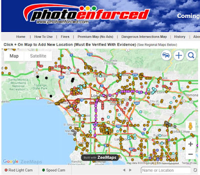
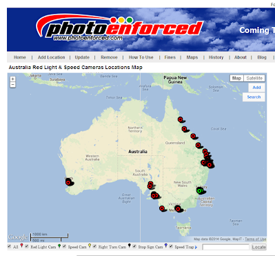
With mainstream mapping tools reluctant to offer full camera visibility, independent websites and apps are stepping in to fill the gap. Platforms like Speedtrap.org, PhotoEnforced.com, and various Reddit forums crowdsource camera location data and provide regularly updated maps.

In fact, sites like DIYIceBaths.com (in an upcoming article) are compiling detailed speed camera lists by city, starting with Chicago's expansive camera network. These platforms offer not just locations, but context—such as when the cameras are active and which ones are most ticket-prone.

Conclusion: Transparency vs. Control

At the heart of the issue is a clash between driver autonomy and centralized control. Mapping companies may cite safety, compliance, and legal complexity as reasons to hide traffic camera data, but users are growing increasingly skeptical. In a digital era built on open data and real-time insights, the decision to withhold information feels outdated—and potentially manipulative.

If companies like Google and Apple want to maintain user trust, it might be time to embrace camera transparency and let drivers make informed choices.

Waze Map for Photo Enforced Traffic Cameras: How It Compares

Waze, the community-based navigation app, has become a go-to tool for drivers worldwide, offering real-time information about road conditions, traffic, and even photo-enforced traffic cameras. Knowing where red light cameras, speed cameras, and other enforcement devices are can help drivers stay compliant and avoid fines. But how does Waze’s traffic camera reporting compare to dedicated databases like PhotoEnforced? Let’s explore the features, benefits, and differences to help you make an informed choice.

What Are Photo-Enforced Cameras on Waze? 

How to Use Google Street View for Finding Red Light Cameras

How To View Intersection Street View

How To View Intersection Street View
Google Street View

In today’s fast-paced world, staying informed about traffic regulations and enforcement measures is crucial for safe driving. One of the most effective ways to identify the locations of red light cameras is by utilizing Google Street View. This powerful tool allows you to virtually explore streets and intersections from the comfort of your home. In this article, we will guide you through the process of using Google Street View to find red light cameras and enhance your awareness while driving.

Why Use Google Street View?

Google Street View is an invaluable resource for drivers. It provides panoramic views of streets and neighborhoods, allowing users to familiarize themselves with their surroundings. By using Google Street View, you can:

  • Identify Red Light Camera Locations: View specific intersections where red light cameras are installed, helping you prepare for potential enforcement.

  • Plan Your Route: Navigate through areas you may not be familiar with, making it easier to avoid unwanted tickets.

  • Enhance Your Driving Strategy: Understand traffic patterns and signals at intersections, which can aid in safe driving practices.

Step-by-Step Guide to Finding Red Light Cameras with Google Street View

1. Access Google Maps

Start by opening our maps in your web browser or mobile app. Ensure you have a stable internet connection to load the map data efficiently.

2. Enter Your Desired Location

Type in the address or name of the city where you want to check for red light cameras. Zoom in to the specific area you are interested in, especially near intersections known for traffic enforcement.

3. Activate Street View

Once you are zoomed in, look for the yellow “Pegman” icon located in the bottom right corner of the screen. Click and drag this icon to the area you wish to explore. Streets where Street View is available will be highlighted in blue. Release the icon to enter Street View mode.

4. Navigate the Street View

Now that you are in Street View, you can virtually navigate through the streets. Use the arrows on the screen to move forward or turn around. Pay attention to traffic signals, signage, and the surrounding environment as you explore the intersection.

5. Look for Red Light Cameras

As you approach intersections, keep an eye out for the following indicators of red light cameras:

  • Camera Signs: Look for signage indicating the presence of red light cameras, which often appears near traffic signals.

  • Camera Equipment: Observe the intersection for any camera apparatus mounted on poles or traffic lights.

  • Traffic Patterns: Analyze the flow of traffic and any road markings indicating the presence of enforcement measures.

6. Check Local Regulations

In addition to visual cues, it’s essential to check local traffic regulations regarding red light cameras. Many cities have websites or resources that provide updated information about camera locations, fines, and enforcement practices.

Tips for Using Google Street View Effectively

  • Use Historical Views: Google Street View often has historical imagery available. Click on the clock icon in the upper left corner of the image to see previous versions of the street view. This feature can help you determine if red light cameras were installed in the past.

  • Combine with Local Resources: Use Google Street View in conjunction with local government websites, which often provide official information about red light camera locations and traffic laws.

  • Stay Updated: Red light camera locations can change, so it’s a good idea to periodically check Google Street View for updates, especially if you frequently drive through a specific area.

Conclusion

Using Google Street View to find red light cameras is an effective way to enhance your driving awareness and avoid potential traffic violations. By familiarizing yourself with camera locations and understanding the traffic patterns at intersections, you can make informed decisions while on the road. Whether you're planning a route or simply exploring new areas, Google Street View can be a valuable tool for any driver committed to safe and responsible driving.

Read this if you are unclear about the difference between red light camera and traffic cameras.  Please comment on the discussion page if a camera needs to be removed.  

Tesla's Speed Cameras & Red Light Cameras Database

How accurate and complete is the Tesla database of cameras?

Impact of AI on False Information Using Inaccurate Map Data

Artificial Intelligence (AI) has become an indispensable tool in various industries, revolutionizing how we process and interpret data. However, AI's reliance on data, especially map data sourced from websites that occasionally provide false positives, has raised concerns about its accuracy. In this SEO-friendly article, we will explore the intricacies of how AI generates false information when using map data from websites that may occasionally yield false results.

How Does Google Maps and Waze Determine Traffic Conditions?

Waze vs Google Maps Traffic

Google Maps and Waze determine traffic conditions using a combination of methods:

Red Light Camera Mobile Apps Compared

mobile radar detector apps in Android store
Top Red Light Camera Mobile Apps & Reviews

There are several popular mobile apps available that provide information about red light cameras. However, please note that the availability and features of these apps may have changed since then, so it's a good idea to check the latest information and reviews on app stores before making a decision. Here are a few popular red light camera mobile apps at the time:

Waze: Waze is a widely used navigation app that also provides real-time traffic updates, including the location of red light cameras. It relies on user-generated data to alert drivers about red light cameras, speed cameras, and other potential hazards on the road. Waze is available for both iOS and Android.

TomTom Speed Cameras: TomTom is a well-known navigation company that offers a dedicated app called TomTom Speed Cameras. It provides alerts for various types of cameras, including red light cameras. The app includes features like speed limit warnings and traffic information as well. TomTom Speed Cameras is available for iOS and Android.

iRadar: iRadar is an app developed by Cobra Electronics, specializing in radar detection devices. The app provides information on red light cameras, speed cameras, and other potential traffic enforcement zones. iRadar also offers community-based features where users can report and verify camera locations. The app is available for iOS and Android.

RedZone Map: RedZone Map is an app that focuses on providing real-time information about various road hazards, including red light cameras. It uses a combination of user reports and data from other sources to alert drivers about potential camera locations. The app offers additional features such as crime data and road condition updates. RedZone Map is available for iOS and Android.

Escort Live Radar: Escort Live Radar is an app developed by Escort, a company known for its radar detection devices. The app provides alerts for red light cameras, speed cameras, and other enforcement areas. It also features community-based reporting where users can contribute and verify camera locations. Escort Live Radar is available for iOS and Android.

Please keep in mind that the accuracy and reliability of the camera data provided by these apps can vary, as they rely on user-generated content and other data sources. It's advisable to consult user reviews and check for recent updates to get the most up-to-date and accurate information before using any of these apps.

As a reminder, we don't have a mobile app.  However, you can the Photo Enforced website on your mobile phone app or iPad app without downloading it. 

Apple Maps Speed & Red Light Camera Reviews

Apple Maps red light cameras and speed camera

Google Maps and Google-owned Waze, the popular driving navigation app, both already include these features. Waze has let drivers report and flag known camera spots and speed traps for years. It backed away in recent years from displaying police checkpoints, like those set up to snag drunk drivers. 

 We are curious where Apple Maps is publishing speed cameras and if these locations are accurate?
Apple is adding multiple new features to the Maps app in iOS 14, including Apple Maps icons that will let users know when they're approaching speed cameras and red-light cameras along a route.

It's not clear if this feature will be limited to select areas, countries, or will have a wide rollout, and it does not appear to be implemented in the initial ‌iOS 14‌ beta as an examination of the Maps app with various routes did not display icons for traffic cameras. 
   
While MacRumors took a look at the iOS 14 Maps app this week and couldn't find any traffic camera icons, it looks like there may be more to the CarPlay feature, as one Reddit user discovered. Google is testing a new feature in Maps that lets users report accidents and speed cameras. The feature, introduced in the latest version of Apple's map operating system, Apple Maps, displays a small speed camera icon at a point on the map where users report seeing a police speed trap.  
    
So far Apple hasn't really said much about how it will work, but I've listed a few examples of maps that should let you know when you get close. Google Maps shows you the location of the speed camera on your planned route and plays an audio cue on the map that tells you when you need to approach it. Apple Maps does not detect speed, it will try to give you data about speed limits, but will not inform you about changes. This information would be useful in both Apple Maps and CarPlay, so I'm curious to see if it works when I approach it. 
    
If you are in an area where the speed limit has fallen, Google Maps will notify you if there is a speed trap in front of you. The app logs your speed as you approach the limit and also shows you its location, and warns you if you do, so you should slow down and watch your surroundings.
       
The company has been working diligently on a massive maps update, and now comes Apple's biggest update in history, taking Apple Maps and other app features to a whole new level. If you're wondering why Apple Maps isn't getting out - looking at improvements in iOS 12, here's the answer: The company's long-term plans for the Maps app on iOS are much longer than that. The maps have been updated and have more features than ever before, including the ability to update maps, as well as a number of new features, such as speed cameras. Apple Map is currently available on the App Store for iPhone, iPad, iPod touch and iPad Air 2, but will also be available on Android phones and tablets. 

Please give us your feedback below on the data Apple Maps is publishing. Are they missing locations and are they accurately reporting in markets worldwide?
    

When Will Google Maps Sync With Traffic Lights?


According to this article, Google is experimenting with showing traffic lights in Maps

Google Maps is experimenting with a new feature that displays traffic lights directly in Maps and assumes this will be for Waze also. Traffic lights will be visible both while navigating or simply browsing around.

This doesn't mean that the red lights, yellow lights, green lights will be displayed immediately.  It will likely just be a database of traffic lights and locations.  This is what it will look like below on Google Maps.


Real-time signals would be very cool.  There is a company called Connected Signals which connects the traffic signal to the cloud and will allow mapping companies to display and optimize traffic using these signals. 


Connect Signals has a product called Transit Signal Priority (TSP), automatic Pedestrian Signaling (PedSig), and a variety of other applications without requiring the acquisition and installation of additional capital infrastructure, including roadside equipment such as special-purpose optical or radio-frequency devices or DSRC installations. The system’s key innovations are its use of existing infrastructure (including the public cellular network and the city’s Traffic Management System (TMS) and traffic network) to securely provide these capabilities, its use of mobile devices to request action from the signal network, including pedestrian walk signals, and its software-defined nature that supports extension and modification of capabilities without requiring hardware modifications or field-service modifications.

How Does Google Maps Know Traffic?


Google Maps continually refreshes based on anonymously tracked user data in mobile apps, traffic light camera sensors & ALPR traffic cameras, and satellite data to make sure the app is displaying the most accurate traffic conditions possible.  Traffic data is also sourced by the wireless carriers AT&T & Verizon with vehicle data.  Ever wonder why your car is giving you free navigation data?  This is why because they are using your data to measure traffic.  What is ALPR

If you’ve ever used Google Maps, you’ve likely seen streets colored green, orange, or bright red if you live in a major city. Green roads mean traffic is moving normally (hardly ever), but orange and red represent slowdowns. Red slowdowns show up on the map when users in navigation mode are currently traveling at slower-than-usual speeds on that part of the road and are applied by Google automatically. However, once other divers using Google Maps are able to get through the area at higher speeds, Google will remove the slow down status for that location even if other users are still driving slower.

How Are Accidents & Slowdowns Reported? 

It’s unclear how many alerts are necessary for Google Maps or Waze to register it a slow traffic location or accident, but according to some experiments, it only took a single car driving faster to undo the traffic jam map status.

That said, it appears that Google Maps ignores when lots of users are at a standstill. Interestingly, not all vehicles are treated equally. Google Maps can tell the difference between a car, motorcycle, and other vehicles (at least in certain countries and regions). So even though a fast scooter might be able to weave its way through a traffic jam, Google Maps could—in some cases—recognize that the smaller vehicle’s movement doesn’t necessarily mean that regular traffic conditions have resumed.

Google Maps also updates traffic reports based on user input like Waze in addition to passive, anonymized location and movement tracking to help keep conditions updated.

Accidents, construction zones, speed traps, and other alerts can all be reported in Google Maps & Waze, and the more users that report an alert help it show up faster on the map for others and potentially help them avoid slowdowns and find better routes if necessary.  While in Google Maps’ navigation mode, tap the “+” icon (third icon down on the right-side menu). 

How Does Google Maps Reroute and Calculate Estimated Time of Arrival (ETA)

Google compares the speeds of its Google Maps users with speed limit information to calculate estimated arrival times. Basically, it takes how fast you’re actually moving, how fast you should be moving based on speed limits, how fast other drivers are going and adjusts how, and how much further you have on your route to determine your ETA.

Google Maps will also cross-reference user-reported conditions and other traffic data is monitors with your route and current speeds, and will adjust your arrival times if it notices a slowdown or other incidents along your route. Once the app has determined the severity and length of the slowdown, it will alert users whose routes are affected and suggest alternative directions if it’s ultimately faster.

Google Maps and Waze reroute suggestions aren’t always perfect, however. The algorithm can only respond to the most recent data and make a guess—it certainly can’t tell the future, either—so rerouting won’t always be faster (or necessary).  Read more about this study

Live Traffic Cameras Mobile App

Photo Enforced Live Traffic Mobile App
Live Traffic NYC Mobile Web App

Add Traffic Cameras Mobile App to Home Screen
How to Add Our Mobile Traffic Cameras App to Phone

red light cameras mobile app map of speed camera locations nearbyMap of traffic cameras nearbyFind toll road camera locations nearby
All of our maps are free mobile friendly pages that can be easily bookmarked on your phone using a Safari browser on the ihttps://www.photoenforced.com/Live-Traffic.htmlPhone and Chrome browser on an Android phone. These maps will never require a download and the home screen icon does nothing in the background unless you are using the app. Its like a shortcut to a browser but on your phone and the icon is easy to find and quick to use with no sign-in required. These maps are all advertising supported.

When you open the map it will automatically find your location and display data relevant to your area. Each map has its own unique icon depending on which data you are interested in. The default map is all cameras but you can choose speed cameras, red light cameras, traffic cameras below.

Here are details below on how to add to home screen.

How to Add Home Screen Ico

Google Maps 10x Price Increase = Downgraded User Experiences

Unfortunately, Google Maps has raised pricing by 10x on us and ZeeMaps.com.  This price hike has forced us to publish our map data using Google Fusion Tables. Should you wish to search or add new locations to the map please use our regional state and city pages where we will continue to use the ZeeMaps data management service.

We are now obligated to pay Google Maps a $5 CPM (.50 cents previously) to publish our maps while we only average approximately $3 CPM from Google Advertising.  If you do the math that means we are losing $2 per thousand visitors now if we continue to use Google Maps.  Before the price hike, we could make a reasonable but not greedy $2.50 per thousand visitors. Publishing map data is not exactly a profitable business anymore.

We apologize for your downgraded experience and you can thank Google Maps no flexibility on pricing model for startups or companies that are virtually non-profit.

How Use Google Map Layers Instead of Waze


How many times have you used Waze and a false camera has been reported?  If you are like me there are a lot of false positives in the map database.  Most drivers do not understand the difference between traffic/license plate camera readers and red light camera/speed cameras.  We know this because of the thousands of clarification questions we get each year from readers.

Most people don't want to download and use multiple navigation apps.  So, Google My Maps is currently the best way to keep track of the places that matter to you. This free service allows you to easily make custom maps to remember locations such as red-light cameras and speed cameras.   Download the Google My Maps here and use it along with Google Maps.  This is a great way to integrate your personal map data onto your Google Maps.

We hope that Google Maps will eventually make this as easy to use as the traffic layer option.  We would like to use a Google Maps layer of camera data similar to traffic,  This way users could add voice/visual notifications of when approaching a dangerous intersection, speed cameras, and red light camera locations.

How to White List Sites on Ad Blocker


Advertising revenue is how we maintain this web site and when you have an ad blocker running we don't make any $. We have a smart sophisticated audience and I think up to 50% of our audience is using ad blocker software. Our sites do not use annoying pop-up ads and only use Google Ad Sense and Media dot net. Thanks for your continued support for the last 15 years!


Is the PhantomAlert vs Waze Lawsuit Over?

Judge, siding with Google, refuses to shut down Waze in wake of alleged theft by PhantomAlert. "This rule applies even when the 'facts' are inaccurate."

Google, the owner of the traffic app Waze, has managed to beat back a copyright lawsuit filed by lesser-known rival PhantomAlert. Back in September 2015, PhantomAlert sued Google over allegations of copyright infringement. Google purchased Waze in June 2013 for over $1 billion. PhantomAlert alleged that after a failed data-sharing deal between itself and Waze collapsed in 2010, Waze apparently stole PhantomAlert’s "points of interest" database. In a judicial order filed earlier this month, the San Francisco-based federal judge found that PhantomAlert could not allege a copyright claim on simple facts of where different places actually are. As US Magistrate Judge Joseph Spero wrote, granting Google's motion to dismiss:

The Supreme Court has made clear that facts are not copyrightable, though the creativity associated with the selection and arrangement of those facts in a compilation may be protectable (as discussed below). See Feist, 499 U.S. at 347-48. This rule applies even when the "facts" are inaccurate, as was the case in Feist, where the defendant had copied a handful of false listings that were "seeded" in the plaintiff’s directory. Id. at 344.

While it is possible to assert copyright over a set of facts that are arranged or organized in a particular way, the court found that PhantomAlert had not done that. As Judge Spero continued:

Here, Plaintiff has not alleged any specific facts that suggest that the arrangement of the information in its Points of Interest database is characterized by any originality. There are no allegations that the data is organized into categories, for example, or that there is anything creative about the way the data is displayed. Further, to the extent Plaintiff alleges the information in the database is edited so as to alert the driver of the Point of Interest before reaching the actual location, see Compl. ¶ 22, there appears to be no creativity involved in these changes. As discussed above, the arrangement of the Points of Interest on the map merely effectuates the purpose of the database; presumably, any app intended to alert drivers of the types of points of interest contained in Plaintiff’s database would make very similar changes.

However, the judge will allow PhantomAlert to file an amended complaint no later than mid-January 2016.

"We look forward to amending our complaint to reflect the significant creativity and judgment that underlie our client's individual data elements, and its compilation of these data into an original database," Karl Kronenberger, PhantomAlert’s attorney, told Ars via e-mail.  

Full Story

Should Uber Drivers Have Photo Enforced Warning Locations On Their Driving App?

The Uber Navigation Should Warn Drivers About Photo Enforced Locations
Submit Your Comments or Suggestions Below

Map of Cities That Have Removed Red Light Camera Locations

Map of Cities That Have Removed Red Light Camera Locations

Anaheim Apopka Bell Gardens Belmont Belmont Berkeley Burlingame Chicago Clive Corona Costa Mesa El Cajon El Monte Emeryville Escondido Fairfield Fresno Fullerton Gardena Glendale Grand Terrace Grand Terrace Hayward Houston Huntington Beach Indian Wells Irvine Laguna Niguel Lancaster League City Loma Linda Los Angeles Monroe Montclair Moreno Valley Murrieta Napa Naperville Northwood Orange Pasadena Poway Redlands Redmond Redwood City Rocklin Roseville San Bernardino San Carlos San Diego San Juan Capistrano Santa Fe Springs South Gate St. Joseph The Woodlands Upland Whittier Yuba City Yucaipa Zachary