Showing posts with label Here. Show all posts

Why Are Mapping Companies Afraid to Publish Camera Locations?

black, red, yellow country shape 

In an age where real-time traffic updates, satellite imagery, and AI-powered routing are commonplace, one question stands out: Why do most mapping companies avoid showing speed and red-light camera locations? With drivers increasingly reliant on navigation apps like Google Maps, Apple Maps, and Waze, the lack of transparency around traffic enforcement camera locations raises serious concerns about data censorship, user trust, and government influence.

The Growing Demand for Camera Location Transparency

Speed and red-light cameras are now widespread across major U.S. cities—from New York to Chicago to Los Angeles. These cameras are marketed as tools to improve public safety by deterring dangerous driving behaviors. But many critics argue they're also a revenue-generating tool for municipalities.

For drivers, knowing the location of speed and red-light cameras isn't just about avoiding tickets—it's about making informed driving decisions. That’s why demand for apps and websites that publish camera locations has skyrocketed. So why aren’t the biggest names in mapping fully supporting this?

1. Legal and Regulatory Pressure

Mapping giants operate globally, which means they face a complex patchwork of local laws and regulations. In some countries, publishing the location of speed enforcement cameras is outright banned. Even in the U.S., some jurisdictions have lobbied against features that reveal camera locations, arguing it undermines public safety efforts.

Is It Illegal in Germany and Europe?

Yes—and this is a major reason mapping companies remain cautious.

In Germany, it is illegal to use or operate apps or devices that provide real-time speed camera alerts while driving. Section 23(1c) of the German Road Traffic Act prohibits using such functionality in vehicles, and violators face fines and points on their license. Passive knowledge (like memorizing camera locations or checking before the drive) is allowed—but live alerts during driving are banned.

Here’s a snapshot of laws in Europe:

Country Legal to Use Speed Camera Alerts While Driving?
Germany ❌ Illegal
France ❌ Illegal (workarounds like "danger zones" used)
Switzerland ❌ Very illegal—even owning the app
UK ✅ Legal for fixed cameras
Netherlands ✅ Generally allowed
Italy/Spain ✅ Mixed enforcement

Because mapping companies often deploy uniform global features, they tend to restrict or blur enforcement camera data in countries with strict laws—sometimes impacting their features even in more lenient regions.

2. Fear of Political and Governmental Backlash

Publishing camera locations can put tech companies at odds with local governments and law enforcement agencies. These partnerships are often essential for access to infrastructure data, transit updates, and emergency response systems.

Criticizing or circumventing traffic enforcement tools might jeopardize those relationships. For some companies, avoiding conflict with city governments is more important than serving driver interests.

3. Liability and Public Safety Concerns

Mapping companies must also weigh ethical concerns. Critics of camera alerts argue that making camera data widely available could encourage reckless driving—drivers might only slow down near known camera points and speed elsewhere.

This puts companies in a tough position: if someone misuses the information and causes harm, could the platform be held partially responsible? To avoid these murky liability waters, many simply choose not to include real-time camera data.

4. Data Sourcing Challenges

Another overlooked factor is data reliability. Camera installations frequently change—new ones are added, and older ones are decommissioned or relocated. Maintaining an accurate, up-to-date global database of camera locations is a monumental task that requires constant local data verification.

Crowdsourced platforms like Waze have made strides in this area, but even then, accuracy varies widely by location. This makes it hard for major players to justify large-scale implementation, especially if the data can't be verified.

5. The Rise of Independent Alternatives

With mainstream mapping tools reluctant to offer full camera visibility, independent websites and apps are stepping in to fill the gap. Platforms like Speedtrap.org, PhotoEnforced.com, and various Reddit forums crowdsource camera location data and provide regularly updated maps.

In fact, sites like DIYIceBaths.com (in an upcoming article) are compiling detailed speed camera lists by city, starting with Chicago's expansive camera network. These platforms offer not just locations, but context—such as when the cameras are active and which ones are most ticket-prone.

Conclusion: Transparency vs. Control

At the heart of the issue is a clash between driver autonomy and centralized control. Mapping companies may cite safety, compliance, and legal complexity as reasons to hide traffic camera data, but users are growing increasingly skeptical. In a digital era built on open data and real-time insights, the decision to withhold information feels outdated—and potentially manipulative.

If companies like Google and Apple want to maintain user trust, it might be time to embrace camera transparency and let drivers make informed choices.

Here / NAVTEQ Reluctant to Use Crowdsourced Data Still?

NAVTEQ/HERE Technologies has historically focused on utilizing various data sources, including sensor data, official sources, and partnerships with car manufacturers and other entities, to create and maintain their digital maps and location services.

Crowdsourcing, which involves gathering data from the public or users, is a commonly used approach in many mapping and navigation services. However, specific companies may have their own strategies and preferences when it comes to data acquisition.

It's possible that NAVTEQ/HERE Technologies has chosen to rely less on crowdsourcing and prioritize other data sources and partnerships to ensure the accuracy and reliability of their mapping products. However, I cannot provide information on their current beliefs or strategies since my knowledge is based on information available until September 2021. For the most up-to-date and accurate information, it would be best to refer to official statements or communications from NAVTEQ/HERE Technologies themselves.

Nokia Navteq Acquired Trapster in 2010

Pete Tenereillo, the founder of Trapster has apparently been acquired by Navteq / Nokia.  Navteq is a struggling  Chicago-based mapping company, that is a division of Nokia which is another struggling mobile phone maker that is quickly losing market share.  AutoBlog broke the news and said there were about five companies in the running and there was a bidding war for the company. The terms of the deal are not available. We are waiting to hear back from Nokia and Trapster.   

Pete is an engineer and a sports car enthusiast who founded the company to primarily help his fellow drivers slow down when police were near while driving through the roads of San Diego.  We met with Pete when shortly after he launched the application and only had a few hundred thousand users.  The company interested in working with us to verify our database of the fixed red light camera and speed camera locations.  We never licensed our database to Trapster but they suspiciously had most of the locations shortly thereafter.  It is not clear how they accumulated the locations in their database nor do we know how many they have. 

It has been wildly reported how many downloads they have for their application but no one ever seemed to know how many users they have on a regular basis to keep the data fresh.  The application has apparently received 9M downloads and is free.  It's very common for iPhone applications to have many downloads but a non-existent user base.   However, Trapster likely has many hundreds of thousands of users who share data, and it's impressive how they have scaled this capability as a small company.  

It's not clear if Trapster ever generated any subscription or advertising revenue from it but we don't think so. Trapster raised an angel round of fewer than one million dollars a few years ago and is based in San Diego.  We are not sure if they ever raised any more money than $1M or a VC round.  However, we would like to congratulate them on raising awareness about the application and accumulating so many users.  

As a disclaimer, we publish an open database of the fixed red light camera and speed camera locations and don't do a lot to prevent companies and people from copying it.  However, we are the largest database and most accurate database of red light cameras do date and no other companies have accepted our challenge to do a database comparison.  We do have a number of companies who license our database and are ethical about paying us for the data they use.  

It's great to see the company get acquired as there are several companies developing applications in Europe that are interested in coming to the US.  Europe has 40,000+ photo-enforced cameras and it's a much larger and more mature business over there.  The US currently has only about 6,000 cameras but it's growing at a rate of about 20% per year. 

However, it's important to note that my information might not be up to date, as corporate acquisitions and developments can change over time. To get the most accurate and current information, I recommend referring to reliable sources or conducting a search for the latest news and updates on Nokia's acquisitions and Trapster.

What is NAVTEQ Worth To Nokia?


Nokia purchased NAVTEQ / Nokia (NYSE: NOK) for $8.1 billion dollars in 2007 when Nokia's stock was trading upwards of $30+ dollars per share.  Now Nokia's stock is trading at less than $6 per share and sinking.  Nokia's market cap is approximately $20B with annual sales of $55B.  When Nokia purchased Navteq it had a market capitalization of $120B.  So this begs the question of how much is NAVTEQ worth to Nokia these days?  It appears that NAVTEQ will do €600 million in revenue ($1B in US dollars) in 2011 while still losing money.

With Nokia struggling to get traction in the smartphone space it makes sense that NAVTEQ could be a ripe buyout candidate from a company like Microsoft or Apple who desperately need a map platform.  NAVTEQ products embedded in just about every car that has a navigation system embedded in the car.  Overprice I must say but the car manufacturers are selling the software for thousands of dollars when Google Maps is free.   Google Maps on the other hand is free but ad support and works great for most smartphone users.  Google Maps is not as reliable as NAVTEQ for navigation but it gets the job done at a fraction of the cost.  

Crowdsourcing Traffic Companies

The telematics, mapping, and mobile applications industry is growing and so are crowdsourced traffic companies.  The race to build or acquire the biggest crowd data has taken hold with the first acquisition of Trapster by Nokia / Navteq. Navteq reportedly outbid by five other potential acquirers. Trapster attracted a large app following putting it ahead of TCS / (Networks in Motion) with about five million probes, but behind Telenav, with more than 17 million. Who else is in the game? Onstar, RIM, Google, TomTom, Inrix, Waze, Telmap who track the mobile phone and device location speeds.  Read more in the article The Race to Scale Crowd-Sourced Traffic Data is On.

How do map companies get traffic data?  These hardware and software companies have access to the GPS feeds associated with your mobile device or phone and use it to map traffic on maps.  They also accept reported incidents from users and have tools to filter the information before publishing.  Trapster had many locations reported by users but it was never very clear how the filtering process worked and how many false positives they had by spammers using the app.  These are some of the filtering challenges companies like this face as the source data on the handset.

Trinity Red Light Camera Database Questions


I am continually amazed at how companies who sell radar detectors and our red light camera database competitors claim to have a more comprehensive database than we do.  PhotoEnforced.com was the first US company to start sourcing this data back in 2000 and our next competitor did not come onto the market until 2005.  How do they do it?  Well, they copied our free database online and started adding to it and selling it as their own proprietary database.  Simply ask the next time you want to license Trinity's database when they got started collecting the data and how they did it.  You probably won't get a straight answer because they will never admit that they stole information from PhotoEnforced.com.  Photoenforced.com has 7,000 - 8,000 locations in our database as of today and it's growing every day.  We also have removed hundreds of locations from our database that are inactive or not accurate.  What another competitor can claim they have a comparable database that is free?

I have asked several of these companies including to do a public "bake-off" comparing the number of locations in their database.  Still, no one wants to compete with crowdsourcing or user generated content because our competitors say they get too many false positives.   Here is what Trinity claims on their web site. Trinity is more accurate and complete than other databases because our team gathers more data than anyone else, to give you the most detailed alerts on the market.  In addition to the camera locations themselves, we plot:
  • the camera type
  • directional vectors
  • speed limits (where applicable)
  • ticket directions
  • “no ticket” directions
When it comes to camera location data, accuracy is key. One of the reasons why Cheetah detectors are better than others is that our proprietary database is 100% verified by Cheetah’s professional database team, which monitors all media and internet channels as well as communicating directly with police departments, city traffic engineers, city records, Municipal Codes of Ordinances, traffic bureaus, state transportation agencies, our own network of trusted camera spotters and field survey teams.

Why doesn't Trinity publish the locations in the database?

Here is a response from Trinity on their Facebook page. Comparing the number of locations won't give an accurate measure of the quality of the Trinity 2.0 database compared to other databases. For example, some other companies actively promote they have camera numbers into the millions, which would lead to extensive numbers of false alerts. We take great care to verify our camera locations are accurate and update regularly.

PhotoEnforced.com Response

Photoenforced.com started collecting the 10 years ago and have cameras in 1200 markets. It's impossible to gather the data without crowdsourcing. I agree that verification is important but that is why we have 2000+ people per day coming to PhotoEnforced.com and using the database. Not even Google or Navteq with all its resources can verify locations. It's a false claim and your database will always be behind the curve. Post settings Labels Data, Database, Google, Google Maps, Navigation, Navteq, red-light cameras, Traffic, Trinity Published on 10/18/10, 4:11 PM Pacific Daylight Time Links Location Search Description Options Custom Robots Tags default

Navigation + Cell Phone Terminal Mode

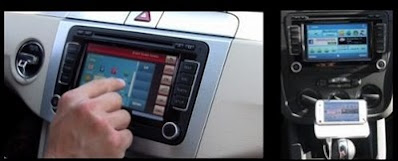
Here is some new technology that allows cellphones to be used as navigation devices in cars, putting more pressure on the makers of in-car satnav systems. German car industry group Consumer Electronics for Automotive (CE4A) unveiled a standard for the technology, which is being pushed by Nokia, the world's largest cellphone maker.

The personal navigation device (PND) industry, led by TomTom and Garmin, has been hit badly by competition from Google Maps navigation-enabled smartphones. When the new "terminal mode" standard is included in cars -- likely starting next year -- it enables consumers to plug wire to their smartphones in the car and without any additional setup issues to use the navigation or other features of their phones directly from a screen built into the car.

Consumer adoption will however take time, industry players and analysts say. "Immediate impact of this is limited, but if you get a credible, good enough experience from the phone navigation in the car -- it removes the need to have any PND," said Tim Shepherd, an analyst with research firm Canalys. Navteq, the world's largest digital mapping firm, said it was seeing interest in the new technology across the industry. "We have seen a lot of interest in terminal mode from system vendors and OEMs (original equipment manufacturers)," Navteq's Chief Executive Larry Kaplan told Reuters in a recent interview.

NAVTEQ a Media Company?


NAVTEQ wants to become a media company but has no intention of selling directly to consumers. I scratch my head hearing the contradiction? I was at the Navteq Connections Conference today and heard some contradictions in strategy and customer focus. As long as they continue to have a developer-centric approach they will continue to fall behind.  Developers need a platform that has wide adoption like Android.  I am not sure that just a platform encourages developers to use it without some unique content.

Google Maps realizes its unique content and Navteq is far from a media company.  Media companies are all about unique content creation similar to what it had Traffic.com.   However, it seems to want to morph this organization into an ad network. What's missing to become a media company? Content and eyeball creation.  Navteq needs to take a more aggressive stance in the online publishing world if they truly want to become a media company.  They should be buying companies like PhotoEnforced.com and GasBuddy.com and provide proprietary content for their customers. Navteq seems content trying to court the large automotive car companies like Ford who are 5 years behind in the content business from smartphones.

Traffic Location Based Mobile Phone Ads

old iphone
NAVTEQ, the global provider of maps, traffic and location data enabling navigation, location-based services, and mobile advertising around the world, has released results of a new survey that shows 78% of consumers welcome ads on their connected mobile devices when those ads are intelligent enough to know where the end-user is and can go on to guide them to nearby retailers and offers, and when the ads offset the cost of other high-value content.  This announcement also supports the business case of rival Google Places which might soon be providing free wireless location-based advertising applications and services.

Conducted by Marketing Research Services Inc. (MRSI), the survey showed that 78% of consumers are receptive to receiving location-intelligent Location Point ads to offset the cost of value-based content such as NAVTEQ Traffic, a six percent increase over the results of MRSI's first round of research on the subject published in November 2009. The new round of research yielded strong indications that again underscore the power of Location Point in converting passers-by to paying customers. Other findings show:
  • At least 42% of respondents that were exposed to a brand recalled seeing that brand (aided and unaided)
  • Thirty-one percent of respondents who reported seeing an ad on their device clicked on that ad for information to nearby locations
  • In a significant measure of impact, up to 31% of consumers seeing a specific ad went on to visit a store location; of those respondents who visited a location after seeing an ad, 53% said they did so directly because of the ad
  • Nine percent of respondents who visited a location because of seeing an ad reported it was a first-time visit to that location
  • Most desired ads were considered attractions/points of interest that provided a special offer or coupon, e.g. gas/fuel and restaurant offers
The MRSI-commissioned research surveyed 782 respondents 18 and older experienced with using ad-enabled personal navigation devices.

Launched 18 months ago, Location Point harnesses NAVTEQ's unrivaled location content and capabilities to pinpoint where consumers are, deliver ads and calls to action within a certain distance of advertised points of purchase, and guide them to the doorstep of an advertised retailer. Built-in calls to action including "click to map" and "click to navigate" bolster consumer engagement with ads, drive traffic to advertised locations and make the service unique.

"The survey indicates consumers are receptive and responsive to ads when those ads are contextually relevant. It shows strong, stable consumer acceptance of Location  Point -- and even suggests consumer acceptance grows with continued exposure," said Christopher Rothey, vice president, advertising, NAVTEQ. "Location Point's unique location intelligence is what drives that level of acceptance and make the ads measurably impactful."
 

Cobra Electronics Licensing Data to Navteq?

We are also pleased to announce that we have executed an agreement with a major manufacturer of mobile phones and mobile navigation products to include the AURA (TM) database in their North American and European navigation products that will be released early next year." said Jim Bazet, Cobra's Chairman and Chief Executive Officer.

"This is a significant step in our plan to make AURA the preeminent provider of photo-enforcement alerts globally and is expected to contribute to revenues and earnings in the second half of 2010. Moreover, PPL generated an increase in sales due to the strength of its new product introductions - mobile navigation products tailored to the needs of the professional driver and the recreational vehicle owner. Cobra has recently launched in the U.S. a mobile navigation product for the professional driver that utilizes this successful PPL platform. We are aggressively pursuing new opportunities and expect a substantial improvement in fourth-quarter results."

Cobra Electronics (Ticker: COBR) Reports Third Quarter Results | Reuters: 

How much due diligence did the "licensee" (Navteq owned by Nokia Ticker: NOK) do on where Cobra acquired the AURA database information and how they plan to keep the information fresh?

See related articles:

Does NAVTEQ Steal POI Data?

thief stealing computer monitor
We would like to alleviate some of the confusion in the marketplace. Navteq is NOT currently a customer of PhotoEnforced.com and we have no idea where they have acquired their data from.

However, PhotoEnforced.com has been the #1 sole source and pioneer of gathering red light camera and speed camera locations in a free open database since 2001. There are many databases in the market described above that copy our data and use this data and sell it. If you are considering licensing or using the NAVTEQ speed and red light camera locations database you might want to ask them the following questions first . . .

1) Why are you missing about 1000+ locations?
2) What sources for acquiring the original 5000 locations?
3) Are your sources for the data-stealing content?
4) Sources for updates on new locations and changes?
5) Proprietary research (?) when PhotoEnforced.com is free?
6) Any right turn and red light camera/speed combo cameras?
7) Why did it take you so many years to release a product?
8) Can you deliver updates to the locations in real-time?
9) How do you charge for the database?
10) Publishing fines with the location be a copyright violation?

NAVTEQ, the leading global provider of digital map, traffic, and location data for in-vehicle, portable, wireless, and enterprise solutions, announced today at Telematics Detroit 2009 speed and red light camera locations are now available for the NAVTEQ(R) map of North America. NAVTEQ Camera Alert(TM) includes up-to-date information about the exact location of speed limit cameras, red-light cameras, as well as combined speed and red light cameras in 5,000 locations throughout North America and Australia.

"Automated cameras are proliferating across North American cities," stated Cindy Paulauskas, vice president of America's map and content products, NAVTEQ. "And our proprietary research indicates that these types of warnings are a highly valued feature in countries where this navigation system functionality is available. Providing our customers with quality North America camera location information helps enable solutions that give drivers better knowledge of maximum speeds and traffic signals - with alerts at the right place and at the right time."

See related posts:
Cobra Electronics Licensing Data to Navteq?
Red Light & Speed Cameras POI Database